

We are awaiting an update on this map. In the meantime , the MRG is designated on Google maps by a rather faint green dotted line.
You have to zoom in at least 3 or 4 times to see the dotted green line that runs from Phnom Phen Sandwich Station on the eastern end to Lebanon Ford on the west where the paved part ends. An unpaved path could take you onto Glen Road. (Glen Road becomes a single lane going under a stone arch bridge so one would need great caution at that point.) Glen Road leads out to RT 12-A, a heavily traveled road where there are a number of shopping plazas and restaurants. (If you move across the map to the east of downtown Lebanon, you will find another green dotted line that represents the Northern Rail Trail with CCBA Witherell Recreation Center as the most evident landmark at Spencer Street. The two rail trails will be connected when tunnel reconstruction is completed.)
Here is an estimate of the mileage between points on the MRG.
Dudley Bridge<.36 mile>PriceChop<.75 mile>MascomaBridge<.28mile >1-89Bridge<.48 mile> SlaytonHill<.6 mile>Kiosk
If you start at the Price Chopper parking lot access on the Miracle Mile (RT. 4/Mechanic St.) and go left (West), it is .36 mile to the Dudley Bridge. If you loop back by way of the path along the river, you will have traveled a .76 mile loop back to the parking lot access road.
If you start at the Price Chopper access road and go right (East), it is .75 mile to the middle of the bridge over the Mascoma River (near Timken.)
Continuing eastward it is .28 mile to the middle of the bridge over Interstate 89.
Then .48 mile from the middle of the Interstate bridge to the middle of the Slayton Hill Overpass by Alice Peck Day Hospital.
It is then .6 mile to the kiosk at the intersection of Mascoma, Mechanic and High Streets.
At some point we will have a map of the MRG drawn to scale . . . but in the meantime, we have these estimates. (Thanks to Paul Coats and Rainie Kelly for the estimates. )
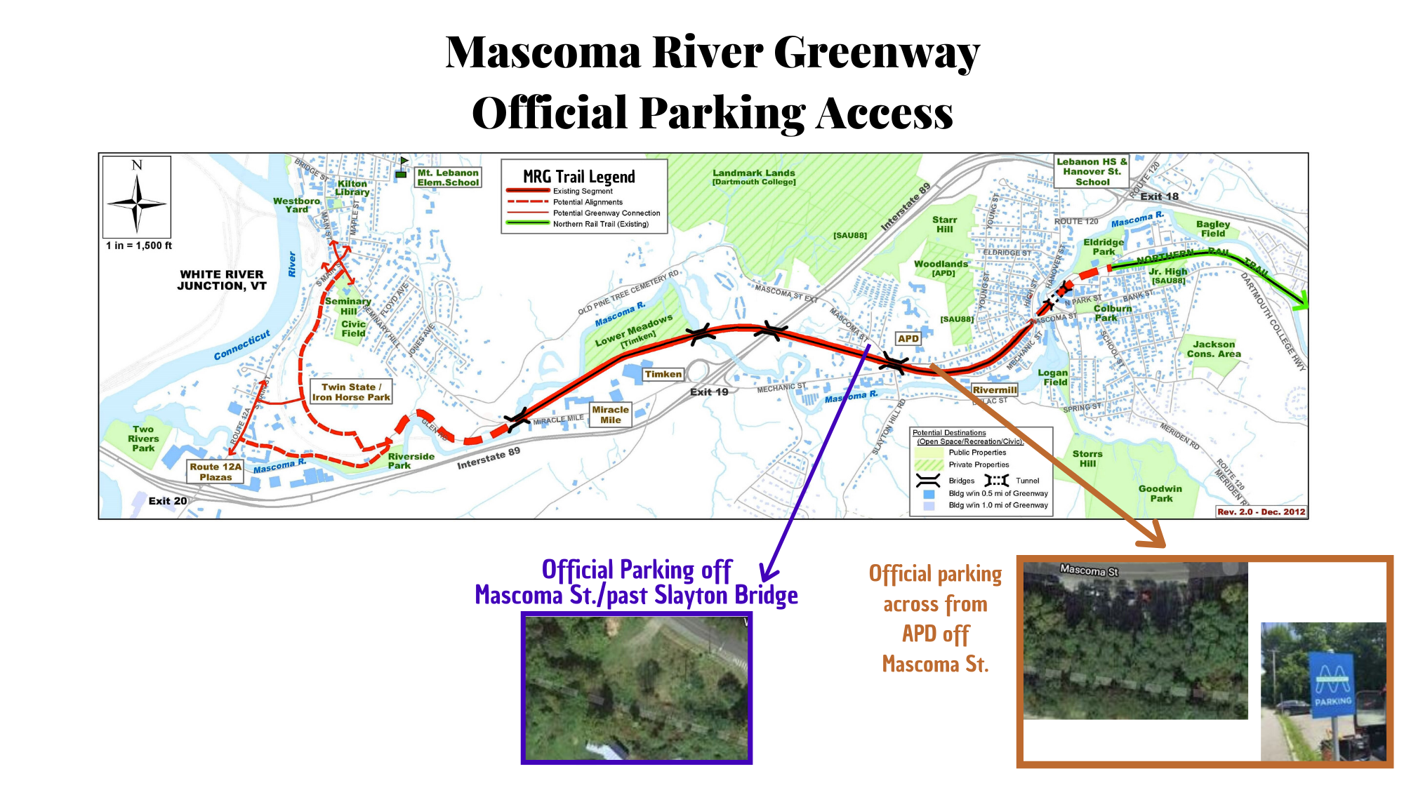
*Please note the above is official parking access to the MRG. We encourage the use of these official access points to encourage the community to get on or off the Greenway.*
Note: Meetings are being planned to problem-solve the two ends of the MRG. (Closure of the downtown tunnel connection to the Northern Rail Trail and failed plans for the Iron Horse Park in West Leb present challenges on both ends.) Also being planned: Kiosks, maps, signage, benches, tables, naming plaques, access points, land purchase, Glen Road options. This is a big project, a marathon not a sprint; Phase 1 is complete but there is more to go!

Do you have a more updated map that shows current completion as of May 24, 2016?
While much construction is being planned for 2016, we have not officially opened any new sections yet. The map provided is still current.
i dont see any mileage markers or even a scale on the map. maybe someone could bike it with a distance computer. I just walked from the APD lot westward to the jersey barriers by the incomplete bridge. I guessed it as 1 mi each way.
Do you have a map showing current status as of June 2018? Or a description. Thanks
The best we can offer at the moment is a description. After Tuesday July 3, the path will be open and paved from High Street/Mascoma Street intersection west all the way to the upper part of Glen Road. Roughly 2.3 miles in length. The Lebanon City Council will be reviewing the tunnel options within the next 6 weeks, which will eventually lead to a decision on how to reopen the path under the mall and connecting the Northern Rail Trail to the MRG. The Glen Road terminus to the West is not the end of our dream. We would still like to connect to Riverside Community Park and West Lebanon Main Street sometime in the future.
So excited about this trail and extension to the Northern Rail Trail. Not being from Lebanon, it would be nice if the map showed access points/parking. Look forward to exploring!
Hi Linda
Sorry I didn’t notice this post in our “pending” folder until today. We have a couple of big access point improvement plans in the works and will be updating maps after we create those points and install kiosks. Thank you
Thank you! Great work!
Good work!! To get to WRJ you should consider crossing the river on the I89 bridge. NHDOT plans to widen the bridge and there is room to add a 10 path. Can provide more details
Alex Vogt NHDOT Retired PE
Just wondering…. does the Greenway actually connect to the Northern Rail Trail now? If not, how would I get from one to the other? I’m looking into doing an overnight bike tour and plan to start in Lebanon and ride south. Thank you for any help you can give.
Hi David, Sounds like a good adventure and a chance to get away from the crowds (and maybe catch some healing sunshine and fresh air?) The quick answer is that the Greenway does not yet connect to the Northern Rail Trail. The MRG project has been in the works for about 20 years and, in the meantime, the railway tunnel that would connect the two trails, has deteriorated and been condemned. Work has begun on tunnel restoration and remodeling of the mall area above. (See https://mascomagreenway.com/2019/05/02/tunnel-restoration-project-presentation/) You could conceivably start at the Price Chopper parking lot on RT 10, walk your bike down the gravel drive that leads to the MRG, ride to the intersection of Mascoma/Mechanic/High Street (by Phenom Penh Sandwich Station) go up High Street , cross over to the Lebanon Mall area, take the sidewalk as far as CCBA recreation center and find the entrance to the Northern Rail Trail there. This would give you several lovely views of the river and the experience of riding on a paved trail . . . but it will only add a little more than 2 miles to your adventure. The MRG is still a work in progress and the hope is it will eventually connect to Vermont trails, but there is a lot of problem solving that still needs to happen.
Hi there! Are there any updates to this map? I am coming from out of town. Riding the northern rail trail and wanting to stay overnight in West Lebanon or White River Junction. Was trying to figure out if this path would get us most of the way from one to the other. Noticing that there’s some comments about tunnels and I’m not quite sure some of the locations for distances. Definitely need to study it more. But was curious if there are any updates. Thank you and looking forward to visiting
Hi Gibby! What you see online is the most updated that we have. The tunnel project is still working on completion. At this time if you are looking to ride the NRT you would be in downtown Lebanon, NH just off of Campbell Street. If you’d like to stay overnight there are options in Lebanon that would be off of Route 120 and a bit of a roundabout way to get there on a bike, but it is possible depending on your comfort level with riding on the road vs riding on the trail. The MRG does not yet connect to VT and we are hopeful for that some day.
I am afraid we do not have an updated MRG map but the MRG is designated on Google maps by a rather faint green dotted line. https://www.google.com/maps/dir/Mascoma+River,+Lebanon,+NH//@43.6389835,-72.2597885,16z/data=!4m9!4m8!1m5!1m1!1s0x4cb4b45628ef6b01:0xb44c5f8d11e82833!2m2!1d-72.2544423!2d43.6411789!1m0!3e1
You would have to zoom at least 3 or 4 times to see the dotted green line that runs from Phnom Phen Sandwich Station on the eastern end to Lebanon Ford on the west; that is where the paved part ends. But you could continue along the unpaved path which would take you onto Glen Road. (Glen Road becomes a single lane going under a stone arch bridge so one would need great caution at that point.) Glen Road leads out to RT 12-A, a heavily traveled road where there are a number of shopping plazas, restaurants, and the Fireside Inn.and Suites . . . more a conference center than a quaint New England inn, but at least accessible . If you move across the map to the east of downtown Lebanon, you will find another green dotted line that represents the Northern Rail Trail with CCBA Witherell Recreation Center as the most evident landmark at Spencer Street. Since the two rail trails are not yet connected (because of tunnel reconstruction) , your best bet would be to continue northwest through the downtown parking lot, bearing to the right, until you reach Hanover Street, take a right, and then a left onto High Street. High Street ends at a rotary and the eastern entrance to the Mascoma River Greenway. You’ll see a garden and kiosk at the entrance.
Eventually the tunnel will be reconstructed and, with time, the hope is that there will be access to VT by way of a trail through West Lebanon. This project has been in the works for more than 20 years and problems have occurred on both ends of the MRG. In the meantime it has been a well-used resource for bikers, runners, dog walkers, skateboarders, roller-bladers, and many more, especially during this time of pandemic.
Thank you! So….it does not go into WRJ…where we were going to stay. Is the a reasonable way to get to the Coolidge Hotel from the end of the Northern, using the Greenway? Is there a bike way over the bridge at all? Otherwise, having trouble finding lodging in town.
Look at the Google map and find Price Chopper. That is the point you will get off the trail (a gravel road leads up to the parking lot – you’ll have to walk your bike up.) Go through the parking lot and out to the main road(RT 10/ RT 4) and turn right and you can bicycle into downtown West Lebanon. Turn left onto Bridge Street. Take a left at the Hartford Town Hall and left on Main Street and you will find the Hotel Coolidge on your right, across from the train station.
You have been INCREDIBLY helpful. Thank you so very much. I am extremely excited now about the trip! Any dinner recommendations? See what being helpful gets you? 🙂
Hi Diane, There are several restaurants within walking distance of the Coolidge Hotel. Trail Break https://www.trailbreakwrj.com/ is a funky pub serving burritos, tacos and other southwestern Fare with a variety of local beers on tap. Thyme https://www.thymevermont.com/ is more upscale . Elixir https://www.elixirrestaurant.com/dinner_menu.html is another possibility. Reservations are probably important since all restaurants are social distancing.
Reservations at Thyme…thank you!! Sooooo looking forward to it!
https://www.openstreetmap.org/relation/9728456
Thank you. This map is so much more accessible!
Pingback: Mud Season – To Hike or Not to Hike - Upper Valley Land Trust